|
|
[China]

Trade Verify
Address: 4F, Building D, Tianyi plaza No.8 West Maodianshan Road, East Lake Hi-tech Zone Wuhan City, China
Contact name:Lanbooxie

Wuhan Geosun Navigation Technology Co., Ltd |
|
Verified Suppliers
|
|
|
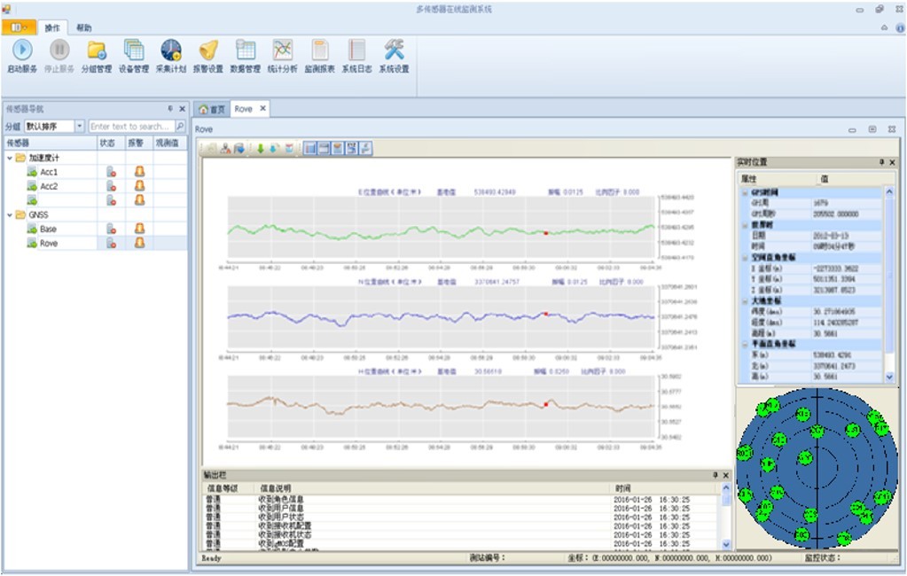
Geosun gMOS is a GNSS real-time high-precise deformation monitoring
system adopting the global advanced real-time high-precise GNSS
dynamic positioning technology, which is different from the
conventional static monitoring method. The system provides 24 hours
per day real-time monitoring of target, and the output frequency is
1Hz. The dynamic 3D monitoring accuracy reaches 3mm. The daily,
weekly and annual statistic report can be easily achieved by gMOS.
Supporting both GPRS and wire network, data can be transmitted
seamlessly.
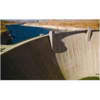
gMOS is specifically designed to detect the slightest deformation
of fixed structures and nature objects, such as dams, bridges,
historical buildings, offshore platforms, oil field, mining,
landslide and etc. For different applications, users can utilize
single or dual-frequency receivers to minimize the cost.
Feature
All-weather 24 hours per day Real-time Monitoring
Different from traditional monitoring methods,gMOS is unaffected by
the climate. The system provides 24 hours per day real-time three
dimensional high-precise monitoring of targets. By directly
processing the raw data from both base station and monitoring
station at the control center,gMOS improves the performance of
real-time and synchronous monitoring obviously.
High Precision
Using the global advanced high-precise GNSS real-time dynamic
positioning technology and related algorithms, gMOS overcomes the
limitations of a variety of conventional GNSS applications such as
electromagnetic interference, block, multi-path, time
synchronization, etc. The system can help engineering researchers
and monitoring managers processing data efficiently, and provide
deformation information at millimeter level.
Intelligent Analysis and Beforehand Alerts
gMOS provides different analysis models for different applications,
which can not only reflect real-time condition of monitoring object
exactly, but also analyze related data intelligently. The system
can help users carry out preliminary risk assessment, and publish
alerts timely in various ways and in different grades. With the
solid technical support and reliable information gathered by gMOS,
the monitoring managers and decision-makers can get to know the
safety condition of the targets, and then choose proper processing
procedure accordingly, so to keep the deformation under the
control.
Distributed Architecture
gMOS adopts client/server distributed architecture. After Stone RT
server is set up, users can install gMOS client on terminal
(equipment supporting network communication, such as PC, mobile
phone, etc.) to connect remote server, and to know the latest real
time deformation information.
Support Various Receivers
gMOS delivers affordable solution on the condition of ensuring the
efficient monitoring and the accurate performance. Giving full
consideration to the actual conditions and the budge of the
project,gMOS supports a variety of mainstream single or dual
frequency GPS receivers to meet customers’ requirements.
Main Functionalities
◆ Graphical and user-friendly interface, 3D graphics monitoring
◆ 24 hours per day real-time monitoring of multi-objects, and the
output frequency is to 1Hz
◆ Analyze the historical data, show the deformation curve of
different period and interval, and show the deformation velocity
◆ Users can save and download the raw data for post check
◆ Spatial location can be saved to database in real time for
inquiry and analysis
◆Distributed architecture, the server is working uninterruptedly,
users can connect server to check the real-time deformation status
in areas covered by communication network
◆ Support GPRS and wire network to transmit data remotely
Accuracy Specifications
◆ Real-time dynamic 3D monitoring accuracy: 3 mm(1σ)
◆ Positioning accuracy of daily monitoring: 1 mm(1σ)