

Active Member
|
[China]

Address: No. 879, Ganghua Road, Hongguang Town, Pidu District, Chengdu
Contact name:admin

Chengdu Wanggan Technology Co., Ltd. |
|
|
S8 GPS land survey equipment
S8 GPS land survey equipment is the final product of S-series, soft black&white screen is good to your eyes and multi-function equipment satisfies you no matter what your mission is. Waypoint, Route, Track and parameter setting could give you an accurate result.
Let's check the details;
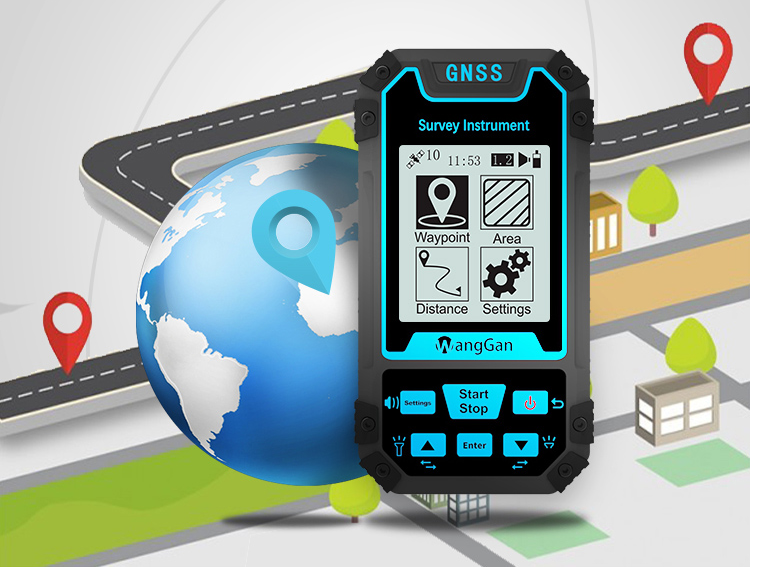
Multi-functional and multi-requirement design Wanggan S8 locator can do altitude survey, position navigation , travel records, accurate positioning and project lofting.

This Wanggan S8 locator device could be used in lots of situations and applicable to a variety of fields, such as electric power circuit, field survey, communication base station, moon and astronomical, land survey, outdoor hiking, outdoor cycling, field exploration and sea fishing
The Function of Lofting
Four Patterns
.(Select Points) Select existing navigation points as lofting points.
.(Equal Division) Setting the number of lofting points,generate equal distance lofting points automatically.
.(Equal Distance) Setting the distance,generate lofting points automatically.
.(User-defined Distance) Setting the distance of the single segment,generate lofting points.
Two Steps
.Select lofting mode
.Accurate lofting following with navigation
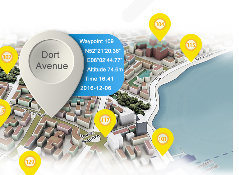
The function of Navigation Point
.Get varied and accurate location information
.The function of taking the navigation point automatically
.The function of inputting the collection navigation point manually

The function of navigation route and track
.Customize edit navigation route(Edit navigation points into route)
.Real-time track recording(Travel records)

S8 tractor makes navigation more direct and convenient, Wanggan S8 tractor has real-time navigation, deviating remainder, speed display, waypoint navigation, route navigation and track navigation.

| Receiver Antenna | Taimeng Passive Large - Size flat plate antenna | ||
| Positional Time | Hot Start Time: one Second; Cold Start Time: 30 Seconds | ||
| Positional Accuracy | Within 2 Meters (HDOP Value Less Than 1.0) | ||
| Area Accuracy | Measurement error is not more than 0.03 Mu (1-3 Mu), 2% (More Than 3 Mu) | ||
| Distance Accuracy | Within one Meter (When HDOP value is less than 1.0 measure the length of 100 meters) | ||
| Functional Characteristics | Coordinate Measurement, Route Edit, Track Record, Navigation Function,Altitude Measurement,Area Measurement, Distance Measurement,Lofting Function | ||
| Data Statistics | Area Statistics, Distance Statistics | ||
| Area Record | 99 pieces | Waypoint Record | 2000pieces |
| Distance Record | 99 pieces | Track Record | 100pieces |
| Route Record | Maximum Number Of Editions 200, Single Route Up To 400 Points | ||
| Track Display | The trajectory will be displayed in real time during the measurement process,and the past measurement figures can also be viewed in the statistical records. | ||
| Barometric Altimetry | About one meter (Barometer measurement, absolute altitude needs to be calibrated) About 10 Meters (GPS Measurement, HDOP value below 1.0) | ||
| HDOP Settings | User-Defined HDOP Setting | ||
| Display Screen | 2.4 Inch, outdoor high- definition black-and-white screen | ||
| Working Temperature | -20"C ~65"C | ||
| Storage Temperature | -40"C~75"C | ||
| Device Size | 117mm*61mm*20mm | ||
| Device Weight | 120 g (Battery Free) | ||
| Data Interface | USB Interface, Which Can Be Charged Through This Interface | ||
| Data Export | √ | ||
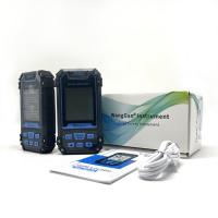
| Standard Configuration | Host*1,Lithium Battery* 1, Charger*1,Data Cable*1, Lanyard*1, Manual*1,Warranty Card*1, Package*1 | ||
Matters need attention
①This product is high precision equipment,Please do not open it privately,otherwise it will be deemed a waiver of our after-sales service.
②This product powered by lithium batteries,do not put it under the sun exposure. For other lithium battery transportation and safety,please refer to relevant national regulations.
③When this product is not used for a long time,please take out the battery.
④Please turn on the product and use it in open area,the effect is the best.
⑤Affected by GPS signal,different regions receive different GPS signals,the measurement results will be inconsistent,this is normal condition,please feel free to use it.
⑥Please use the original charger to charge the device(Do not use non-conforming charger ).
⑦If the content of this manual changes without notice. Please pay attention to our company’s official website:www.wanggan.com, download and update product manual,or ask local distributors for the updated product manual; the right to explain the content of this manual is vested in Chengdu Wanggan Technology Co., Ltd.


