
|
|
[China]

Trade Verify
Address: Room 1118, Block B, 11th Floor, No.68 Tonghe Road, Xixing Street, Binjiang District, Hangzhou City, Zhejiang Province
Contact name:Jianyu Qiu

Hangzhou Blue Aspirations Technology Co., Ltd. |
|
Verified Suppliers
|
|
|

| Modules | Details |
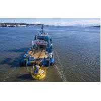
| Buoy | -Diameter: 5m -Height: 9m -Weight: 14.5t -Net Buoyancy: 10.5t -Structure: multiple cabinets -Materials: PE, carbon steel, stainless steel |
| Mooring System | -Water-depth: >5m -Anchor: cement block and/or mooring anchor -Mooring: one-point mooring -Adjustable to suit site-specific requirements including deep water-depth -Multiple mooring system is also available |
| Control System | -Industrial PLC -or BA's embedded controller |
| LiDARs | -LiDARs: Dual LiDAR(default) (Windcube offshore version; ZX 300M, Movelaser B300M) |
| Power Supply | -Battery Capacity: total 60kwh in multiple groups; -Wind Turbines: 2×350W; -Solar Panels: 1600W, multiple groups; - Fuel cells: 2x110W with 224L fuel(optional) |
| Navigation System | -AIS×1 -Radar reflector×2 -IALA-compliant navigation ligh1×-1 Supporting dual navigation light but Need to meet the requirement of local authority |
| Positioning System | -Directions: 0-360° -Direction accuracy: 0.09° (2m baseline) -Positioning accuracy: 0.5m (horizontal, SBAS mode) |
| Motion Sensors | -GNSS-INS sensor×2 or GNSS-INS sensor×1 and MRU sensor×1 |
| Communication Systems | -SAT Modules: Iridium SBD×1, other Broadband SAT data modules (optional); -Mobile Networks: 2G/3G/4G×1; 2.4G/5G Wi-Fi×2; Local Ethernet connection |
| Data Acquisition | -Dual Industrial PCs -Interfaces: serial×6, Ethernet×2 |
Hydrological sensors (optional) | -Doppler current sensor -Wave sensor and water depth sensor -Water salinity and temperature sensor |
With the increasing frequency of human activities in the ocean, protecting marine animals has become increasingly important. Our floating LiDAR system can be equipped with relevant recorder for marine birds/bats and mammals monitoring.
A. Birds Monitoring with Acoustic Recorder
There are many ways to monitoring birds in wildlife, SONG METER SM4 acoustic recorder is a proven industry standard wildlife audio recording equipment, specially engineered to deliver quality sound recordings of birds and other vocal animals in the wild.
This birds acoustic recorder provides high quality recordings with maximize detection and fidelity. The SM4 features two second-generation built-in microphones that create high quality recordings of birds and vocalizing animals. The low-noise microphones have a superior signal-to-noise ratio so you capture more wildlife sounds that matter to you. And the device is quite light and small for installation on the floating LiDAR system.
Specifications
| Recording technology | Two-channel, 16-bit PCM .wav files or compressed .w4v files |
| Recording Bandwidth | 20Hz - 48kHz |
| Sample Rates | The recorder supports the following sample rates in samples per second on one or two channels: 8000, 12000, 16000, 22050, 24000, 32000, 44100, 48000, 96000 |
| Built-in Microphones | l Directional Characteristic: Omni-Directional l Sensitivity: -35 dB +/- 4 dB at 1 kHz (0 dB=1 V/Pa) l Signal to Noise Ratio: 80 dB Typ. at 1kHz (1 Pa, A weighted network) l Max Input Sound Level: 122 dB SPL Typ. |
| Enclosure Environmental Protection | Fully weatherproof |
| Operating Temperature | -4°F to +185°F or -20°C to 85°C |
A. Bats Monitoring with Ultrasonic Recorder
SONG METER SM4BAT FS ultrasonic recorder is the industry-leading bat detector and recorder. It is engineered specially to capture quality ultrasonic bat recording.
Specifications
| Recording technology | Single-channel SM4BAT FS: 16-bit PCM .wav files or compressed .w4v files SM4BAT ZC: Zero-Crossing |
| Sample Rates | Full-Spectrum, single-channel; 192kHz, 256kHz, 384kHz, 500kHz |
| Enclosure Environmental Protection | Fully weatherproof |
| Operating Temperature | -4° to 185° F / -20°C to 85°C |
A. Ocean mammal monitoring with underwater acoustic acquisition device
Our floating LiDAR can be equipped with an underwater acoustic acquisition device, digital Hyd TP-1. It's designed for real-time streaming of digital data for remote storage, processing, and/or visualization. This device has internal processing capabilities allowing, alternatively, to stream results such as spectral analysis. The TP-1 hydrophone is ideal for integration into monitoring buoys or readily existing systems, or it can be connected directly to a computer.
Features
This digital hydrophone features a pre-amplifier combined with a programmable gain amplifier (PGA) with 7 different gains, for convenient adjustment of the overall sensitivity according to expected incoming signals’ amplitudes. The device is equipped with an analog-to-digital converter with a wide range of selectable sampling rates up to 312500 samples per second at 24 bits. The TP-1 is a telemetry-based hydrophone that features a 10/100 MBit/s ethernet interface, which allows direct connection to a computer, or to a wired or wireless network for real-time data streaming to a client that can handle the acoustic data for storage, processing, and/ or visualization. A power/ ethernet cable for power supply and two-ways communications can be supplied.
The TP-1 digital hydrophone has internal processing capabilities, where FFT based data analysis can be carried
out and results can be made available through a low-speed serial link.
It features various configurations, including selectable sampling frequencies, programmable sensitivity, and acoustic data
processing modes.
Specifications
| Sample Frequency | 36.3, 67.8, 78.1, 119.8, 180.2, 156.3, 312.5 ksps (selectable) |
| Sample Resolution | 24 bits |
| Usable Acoustic Band | 1 Hz to 150 kHz |
| Receive sensitivity | -165 to -129 dB re 1 V/uPa at 80 kHz (1x gain) |
| Programmable Gain Amplifier | 1x, 2x, 4x, 8x, 16x, 32x, 64x |
| Input Sound Pressure Level Range | Up to 200 dB re 1 uPa |
| Power Suply | 12 to 24 VDC |
| Operation depth | Up to 100 m |
| Case dimension | 60 x 310 mm (diameter x length) |
| Case Material | Delrin |
| Weight | 0.5 kg (in water), 1 kg (in air) |
| Operation Temperature Range | 0 °C to 40 °C |
Despite the risks of building and operating wind farms in locations prone to severe weather, many of China’s offshore wind farms are developed in high-risk areas. Yet typhoons and other extreme events can pose formidable challenges to wind and met ocean measurement campaigns without proper preparation. As the market leader in China, Blue Aspirations’ floating Lidar system is designed to address precisely these challenges. The system integrates backups for all main components, fuel cells to supplement power from solar panels and wind turbines, and a dual-LiDAR setup in its standard configuration. For added protection, its hull also incorporates a large counterweight and residual buoyancy that mitigates the risk of capsizing or sinking. Truly robust typhoon resilience can only come from sturdy structural design, redundant systems design, and diligent operational support.
CHABA TYPHOON CASE STUDY
On July 1st, 2022 Typhoon Chaba passed through a prospective site for offshore wind farm development in the South China Sea. The site was amid a wind measurement campaign using an industry-standard ZX 300M Lidar integrated into a Blue Aspirations FLiDAR.
Typhoon Chaba originated in the south and headed northwest for several days before landfalling in Guangdong province. Chaba brought maximum sustained wind speeds of approximately 140 km/hr, maximum wind gusts of 170 km/hr, and maximum wave heights of 10.67m. Despite these extreme conditions, our unit continued operating effectively – achieving data availability for all measurement heights at 100%, marking the third occasion this floating Lidar system continued to function without issue amidst typhoon conditions.
We would like to include in this document a summary of the reports from our clients or from third parties nominated by our clients that support our data accuracy and data availability claims.
A summary of the main results is provided below.
| Client | Project Name | Buoy and LiDAR Model | Reference | Issuer of the report | Time | Main findings |
| Blue Aspirations | Carbon Trust OWA Road map Stage 2 Verification (Dundee, Scotland) | BA-FLS-NX5, ZX 300M x 1; Windcube offshore V2 x1
| Offshore Met Mast Inch Cape
| Oldbaum Services from the UK (3rd-party certifier ). DNV will review the final report | 2023.3 - 2023.9 | Interim Stage 2 Assessment Report for Windcube: Duration: 77days; System availability: 100% Data availability: >99.2% for all measurement heights Data accuracy(Wind speed): >2m/s: R2 > 0.991, Slope: 0.995~1.001 4~16m/s: R2 > 0.985, Slope: 0.988~1.001 Data accuracy(Wind Direction): 91m: R2 >0.998, Slope: 1.003, 101m: R2 >0.998, Slope: 1.003, 111m:R2 >0.998, Slope: 1.003, |
| China Three Gorges | Yangjiang, Guangdong | BA-FLS-NX5, ZX 300M | Offshore Met Mast | Blue Aspirations | 2021 | Duration: 2 months; System availability: 100% Data availability: >99.98% for all measurement heights Data accuracy(Wind speed): >2m/s: R2 > 0.9959, Slope: 0.9964~1.0096 4~16m/s: R2 > 0.9921, Slope: 0.9986~1.0122 Data accuracy(Wind Direction): 50m: R2 >0.9987, Slope: 1.0125, Offset:-1.9075 100m: R2 >0.9986, Slope: 1.0198, Offset:-1.4955 |
| China Three Gorges | Yangjiang, Guangdong | BA-FLS-NX5, Molas B300M | Offshore Met Mast | Shanghai Institute | 2022 | Duration: 2 months; System availability: 100% Data availability: >98.5% for all measurement heights Data accuracy(Wind speed): >2m/s: R2 > 0.99, Slope: 1.00~1.01 4~16m/s: R2 > 0.99, Slope: 1.00~1.02 Data accuracy(Wind Direction): R2 > 0.97, Slope: 1.03, Offset: -1.3 |
| Blue Aspirations | Prototype validation, Zhoushan, nearshore | BA-FLS-2.4, ZX 300M | Fixed ZX 300M | DNVGL | 2019 | Duration: 1 month; System availability: 100% Data availability: >97% for all measurement heights Data accuracy(Wind speed): >2m/s: R2 > 0.994, Slope: 0.994~1.003 Data accuracy(Wind Direction): R2 > 0.999, Slope: 0.998-1.002, Offset: -0.83~0.04 |
| Huarun | Cangnan, Zhejiang | BA-FLS-NX5, ZX 300M | Offshore Met Mast | Huarun | 2020 | Duration: 1 month; System availability: 100% Data availability: >96.24% for all measurement heights except 120m (Note: 91.31%, several foggy days) Data accuracy(Wind speed): >2m/s : R2 > 0.9918, Slope: 0.9889~1.0283 4~16m/s: R2 > 0.9851, Slope: 0.9851~0.9938 Data accuracy(Wind Direction): R2 > 0.9981, Slope: 0.9826~0.9961, Offset: -0.758~1.4559 |
Shanghai Institute | Nanhui, Shanghai | BA-FLS-NX5, ZX 300M | Fixed platform ZX 300 | Blue Aspirations | 2020 | Duration: 2 months; System availability: 100% Data availability: >99.7% for all measurement heights Data accuracy(Wind speed, >2m/s and 4~16m/s): R2 > 0.97, Slope: 0.98~1.02 Note: the platform LiDAR has a fatal issue with wind direction thus Wind direction is not compared |
Power China | Shantou | BA4.1S, ZX 300M | 2020 | Duration: 2 months; System availability: 100% Data availability: >99.0% for all measurement heights |

