|
|
[China]

Trade Verify
Address: ROOM A1, 11/F WINNER BUILDING, 36 MAN YUE STREET, HUNG HOM, KOWLOON, HONG KONG
Contact name:Liu

HONG KONG GLOBAL INTELLIGENCE TECHNOLOGY GROUP LIMITED |
|
Verified Suppliers
|
|
|
4k Hd Aerial Photography Camera Drone With Lidar Obstacle Avoidance Rc Drones
This lidar camera RC drone is a professional aerial measurement and photogrammetry drone designed to provide accurate and reliable aerial survey data for efficient and cost-effective survey applications. It is equipped with satellite positioning systems such as GPS/GLONASS and features a maximum ascend speed of 4m/s, take-off weight of about 3178g, wheelbase for foldable operation, and global 4G image transmission with unlimited distance for extended aerial imaging. The Aerial Survey Drone is great for applications and other aerial measurement tasks.
| Attributes | Technical Parameters |
|---|---|
| Flight Control | Compatible with Mavlink Protocol Flight Control |
| 4G Extended Image Transmission | Global 4G Image Transmission, Unlimited Distance |
| Wheelbase | Foldable |
| Battery | 3000mAh |
| Maximum Speed | 17m/s |
| Gimbal | Two Axis |
| Screen Type | LCD |
| Operating Temperature Range | -5-40℃ |
| Take Off Weight | About 3178g |
| Flight Time | 40mins(no Load),29mins(Full Load) |
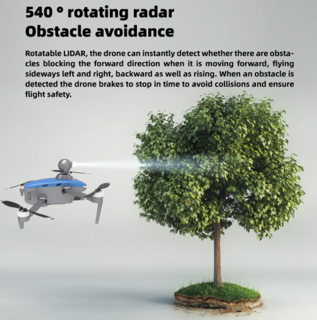
Product Advantages
1. Equipped with rotatable lidar which can detect obstacles around
2. 4K movie grade HD image,8 megapixel, incisive texture
3. 3km image transmission, low latency, strong anti-interference
4. 27 mins flight time,level-5 strong wind-resistance
5. Delay photography function, easy to use
6. 3-axis brushless gimbal supports horizontal and vertical shooting
7. With a key return, low battery return, runaway return, and other intelligent flight modes. when the flight occurs abnormally, the aircraft will automatically return to flight.
8. Working modes: follow me, circle, rocket, dronie, helix, boomerang, flight point, flight route
Product Application