
|
|
[China]

Trade Verify
Address: 508, Building 5A, Fenglongshengang Science and Technology Park, Longgang District, Shenzhen, Guangdong Province, China
Contact name:Wu

SHENZHEN GODO INNOVATION TECHNOLOGY CO., LTD. |
|
Verified Suppliers
|
|
|
Key Features
Digital Twin and Video AR Fusion
Based on 3D live model and satellite map, combined with actual parameters of the drone and 3D simulation of the real-time status, users may directly get the information of drone, such as flight position and flight route. The inspection video of drone is synchronized to the system in real time, and projected to the map through AR, which helps the user quick grasp the field situation and surrounding environment.
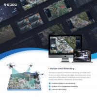
Multiple UAVs Networking
This feature supports simultaneous scheduling of multiple UAVs to carry out tasks, realizing multi-angle video transmission at the same time, and live video of battery swap inside the dock, which enables more effective collaboration as drone fleets.
3D Collaborative Mapping and Surveying
User can conduct mapping and measuring based on satellite maps/3D live models to obtain data, such as latitude and longitude of target, estimated distance of rescue routes, spatial area and so on.
In the event of floods, earthquakes and other geologic disasters, users can combine the real-time video AR projection of drone, to assess and measure the damaged area of the disaster area, area of landslide collapse and other data, as data support for rescue operations.
User can view the flight status of drones and synchronize the drone scheduling messages in real time. The marking and mapping collaboration function allows multiple users to mark, map and schedule at the same time.
AI Recognition & Tracking
This function supports access to various AI algorithms according to different business scenarios, for example, fire and smoke recognition, human-vehicle recognition etc. It supports target tracking based on feature recognition, and intelligently controls the drone and gimbal movements to trace the target.


