
|
|
[China]

Trade Verify
Contact name:Michelle

Chongqing Gold Mechanical & Electrical Equipment Co.,Ltd |
|
Verified Suppliers
|
|
|
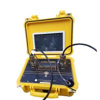
Digital Seismograph Equipment Downhole Seismograph
A downhole seismograph is a device that is used to measure seismic activity within a borehole. It is commonly used in geophysical exploration and oil and gas exploration to gather data on Earth's subsurface, which can be used to make informed decisions on exploration and drilling projects.
Here are the steps on how to use a downhole seismograph:
1. Determine the location for the borehole – The first step is to determine the location of the borehole. This can be done by conducting a geological survey, collecting data on existing geological formations to identify the areas of interest.
2. Drill the borehole – After identifying the location, the borehole needs to be drilled using a drilling rig. The size of the borehole, the depth, and the drilling technique depend on the purpose of the measurement.
3. Install the downhole seismograph – When the borehole has been drilled, the downhole seismograph is installed. The seismograph typically consists of a set of sensors that measure seismic waves.
4. Calibrate the seismograph – Before the measurements can begin, the seismograph needs to be calibrated to ensure accurate readings.
5. Measure seismic activity – The downhole seismograph records seismic activity that can be analyzed later. During the measurement, the seismograph records the vibrations associated with seismic waves.
6. Analyze the data – The recorded data can then be analyzed to identify the type of formation and its properties.
7. Interpret the data – After the data has been analyzed, it can be interpreted to understand the geological properties of the subsurface.
Technical Specification
| Versatile Seismic Recorder | Petroleum exploration and monitoring, engineering studies, depth to bedrock, fault and fracture location, hydrologic investigations, research and teaching |
| Reflection | Suitable for shallow reflection, deep reflection, 2-D and 3-D surveys |
| Refraction | Comes with built-in first break picking and analysis Marine Surveys: Very fast time between shots, real-time single-trace gathers, gun monitoring, noise snapshots, tape swapping for 24/7 operation |
| Sub-bottom Profiling | Works with boomers, sparkers, bubble-pulse sources or air guns |
| MASW | UBC Vs30/ IBC Vs100 Site Classification, microzonation studies (H/V method), foundational engineering |
| Downhole | Compression-wave (P) and shear- wave (S) velocity profiles in geotechnical earthquake engineering investigations. |
Photo of product


