
|
|
[China]

Trade Verify
Address: Building 19, East Dist. R&D Center,#27 Yangqiaohu Ave.,Jiangxia Dist.,Wuhan,Hubei,China
Contact name:lfang

Wuhan Hi-Cloud Technology Co.,Ltd |
|
Verified Suppliers
|
|
|
10cm accuracy 2.5kg HiSLAM for construction of urban underground pipe model
With the rapid development of urbanization, the lag of underground infrastructure construction is becoming increasingly prominent. There are often problems such as repeated excavation of pavement, dense overhead line network, frequent pipeline accidents and so on. The construction of 3D model of underground pipe and its surrounding 3D models above and below the ground can provide realistic and visual 3D model data of the pipe for relevant planning and design departments and construction units, and further improve the scientificity and effectiveness of its planning and construction.
At present, the model construction of urban underground pipe mainly adopts manual interactive 3D modeling, that is, the underground pipe planning and design drawing and topographic map are taken as the basic data, and the 3D model is constructed manually with the help of model building software, which inevitably leads to "distortion". The emergence of 3D laser scanning technology makes it possible to obtain the data of underground pipe and automatic modeling.
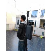
Taking HiSLAM as the point cloud data acquisition equipment, its biggest advantage is that the complete 3D laser point cloud data of the underground pipe can still be obtained according to the SLAM algorithm without GNSS signal. The point cloud data are processed by denoising, resampling, feature point line extraction and triangular surface fitting. Finally, the 3D model of the integrated pipe can be established automatically.
Parameters of HiSLAM
| System Accuracy | ≤10cm(outdoor absolute accuracy) |
| ≤10cm(indoor relative accuracy) | |
| Measurement Range | 120m@20% |
| Scanning Point Frequency | 300,000points/s |
| Panoramic Camera | ≥12MP |
| Data Storage | 512GB SSD |
| Data Transmission | GigE/USB3.0 |
| Battery Life | ≥4h |
| Operation Temperature | -10-50℃,humidity < 85% |
| System Weight | <2.5KG(handheld host) |
| Operation Mode | Handheld/Backpack |
Features of HiSLAM
1. Easy installation: convenient installation, no need to modify the carrier
2. Easy transportation: small size, light weight, convenient transportation
3. Multi carrier: suitable for handheld and backpack mode
4. Integration: highly integrated, indoor and outdoor integration
5. High accuracy: high point cloud density, high point recognition rate, high measurement accuracy


