
|
|
[China]

Trade Verify
Address: Building 19, East Dist. R&D Center,#27 Yangqiaohu Ave.,Jiangxia Dist.,Wuhan,Hubei,China
Contact name:lfang

Wuhan Hi-Cloud Technology Co.,Ltd |
|
Verified Suppliers
|
|
|
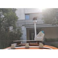
5mm@40m precision 150m/300/600m@90% range 200scans/s HiScan-C LiDAR Mobile Mapping System for open-pit mine monitoring
Slope landslide is a frequent major disaster in the production of open-pit mine. In order to ensure the safe production of open-pit mine, accurate and effective monitoring and prediction of slope landslide is particularly important. The traditional open-pit slope monitoring method is to arrange monitoring points for periodic observation. The traditional monitoring method has the following disadvantages: first, some dangerous areas cannot be reached by surveyors, resulting in the inability of monitoring points to cover the whole picture; secondly, field collection takes a lot of time, and the update cycle is long.
The HiScan series LiDAR mobile mapping system can quickly complete the mapping of the whole mining area. The obtained 3D laser point cloud data has high density and no omission, which greatly improves the refinement of the site measurement data in the mining area. The deformation degree and displacement of the whole slope can be obtained by using the equipped software to register the data of adjacent observation periods.
Parameters of the system
| Type/Model | HiScan-C SU1 | HiScan-C SU2 |
| Number of Sacnners | 1 | 2 |
| Range Measurement | 150m/300/600m@90% | 150m/300/600m@90% |
| Laser Frequency | Max. 500,000 points/s | Max. 1,000,000 points/s |
| Weight | 13kg | 36kg |
| Range Accuracy | 5mm@40m | |
| Angular Measurement Resolution | 0.0088° | |
| Panorama Camera Resolution | 30M pixels | |
| Accuracy | 5cm@100m | |
| Scan Speed | 200scans/s | |
Features of the system
1. Million level laser emission frequency: collect high-density point cloud data and feed back the real information of ground objects
2. 5mm@40m range accuracy: ultra-high point cloud accuracy and more accurate point selection, can be widely used in high-precision application fields
3. High reliability: HiScan-C LiDAR mobile mapping system has high degree of productization, stable and reliable system
4. Lightweight: small size and multiple carriers, greatly reducing the blind area of operation
5. High intelligence: seamless integration of point cloud and panorama


