
|
|
[China]

Trade Verify
Address: ROOM A1, 11/F WINNER BUILDING, 36 MAN YUE STREET, HUNG HOM, KOWLOON, HONG KONG
Contact name:Liu

HONG KONG GLOBAL INTELLIGENCE TECHNOLOGY GROUP LIMITED |
|
Verified Suppliers
|
|
|
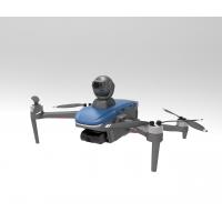
The Aerial Exploration Drone is the best and most advanced aerial drone on the market. It is the perfect tool for aerial photogrammetry and exploration. With a powerful 3000mAh battery, a high-definition LCD screen, and a wide operating temperature range of -5 to 40℃, it can be used in any environment. Its maximum decsending speed of 3m/s allows for rapid and precise aerial maneuvers. The integration of satellite positioning systems such as GPS/GLONASS ensures that the drone is always accurately located and can safely return to its starting point with ease.
The Aerial Exploration Drone is the perfect tool for professionals looking for a reliable and efficient aerial drone. It is the ultimate tool for aerial exploration, photogrammetry, and .
| Aerial Data Collection Drone | Aerial Drone | Aerial Imaging Drone |
|---|---|---|
| Satellite Positioning Systems: GPS/GLONASS | Screen Type: LCD | Wheelbase: Foldable |
| Operating Temperature Range: -5-40℃ | 4G Extended Image Transmission: Global 4G Image Transmission, Unlimited Distance | Max Service Ceiling Above Sea Level: 4000m |
| Maximum Speed: 17m/s | Flight Time: 40mins(no Load) ,29mins(full Load) | Maximum Ascend Speed: 4m/s |
| Flight Control: Compatible With Mavlink Protocol Flight Control |
The Faith2 SE Aerial Survey Drone is the perfect tool for aerial measurement, observation and survey of a wide range of applications. This reliable drone is equipped with a Mavlink Protocol Flight Control, Global 4G Image Transmission, a 3000mAh battery, and a maximum speed of 17m/s. Its operating temperature range of -5-40℃ makes it suitable for all weather conditions. Faith2 SE aerial survey drones are available with a minimum order quantity of 1 pcs, and the price is negotiable. Standard packages are available for delivery within 3-7 work days. Payment terms are available through L/C, D/A, D/P, T/T, and Western Union. The company boast a supply ability of up to 100,000 pcs per month.
Our Aerial Survey Drone – Faith2 SE is the perfect solution for aerial data collection, aerial exploration and aerial measurement. It is equipped with reliable features such as flight control compatible with Mavlink Protocol Flight Control, 3000mAh battery, foldable wheelbase, global 4G image transmission, unlimited distance, and a max service ceiling above sea level of 4000m.
Model Number: Faith2 SE
Place of Origin: China
Minimum Order Quantity: 1 Pcs
Price: Negotiatial
Packaging Details: Standard Packages
Delivery Time: 3-7 work days
Payment Terms: L/C, D/A, D/P, T/T, Western Union
Supply Ability: 100,000 pcs per month
If you are looking for an aerial data collection drone, an aerial exploration drone or an aerial measurement drone, Faith2 SE is the perfect choice. Contact us to get your customized service for Faith2 SE right away!


