
|
|
[China]

Trade Verify
Address: 4F, Building D, Tianyi plaza No.8 West Maodianshan Road, East Lake Hi-tech Zone Wuhan City, China
Contact name:Lanbooxie

Wuhan Geosun Navigation Technology Co., Ltd |
|
Verified Suppliers
|
|
|
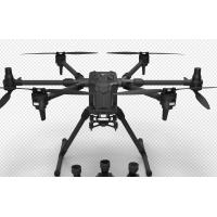
Multi-Rotor Drone Application for Mapping & Survey
The GS-850 is designed specifically for inspection, surveying, security, and wilderness rescue applications. The six-axis aircraft is designed to provide higher levels of safety, power, efficiency, and stability, with the ability to carry heavier payloads. Depending on the effective payload and weather conditions, the longest flight time can reach up to 65 minutes. The GS-850 is equipped with dual IMUs, compass, barometer, dual RTK antennas, and two intelligent batteries, allowing for safe landing even if only five motors are running.
Technical Parameter


Application for Mapping & Survey


