
|
|
[China]

Trade Verify
Address: Building 19, East Dist. R&D Center,#27 Yangqiaohu Ave.,Jiangxia Dist.,Wuhan,Hubei,China
Contact name:lfang

Wuhan Hi-Cloud Technology Co.,Ltd |
|
Verified Suppliers
|
|
|
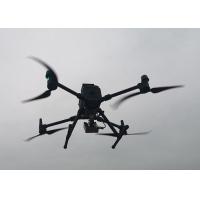
HP3100 UAV flow measurement system is mainly composed of world-famous UAV, professional radar current meter and flow measurement software. With the characteristics of extremely simplified operation, safety, reliability and portability, it can quickly and accurately measure the flow rate data of test targets such as small and medium-sized rivers and large rivers. At the same time, the 15km long-distance high-definition image transmission system can transmit the video image and meteorological information of UAV flight environment to the ground to protect the safety of testers and equipment.The competitive advantages are as follows:
1. Safe and stable flight platform, manufactured by world-famous manufacturers and tested by users all over the world.
2. The stability of PTZ is increased to minimize the impact of aircraft attitude on flow measurement accuracy.
3. 55 minutes long endurance without load, supporting long-distance and multi frequency use.
4. 15km ultra long distance data transmission.
5. Strong environmental adaptability, resistant to 15m / s strong wind and light rain.
6. Fast and flexible, maximum flight speed 23m/s.
7. Six-way positioning obstacle avoidance, automatic recognition of surrounding obstacles, to ensure the safety of every operation.
8. Real-time control of flight information, including wind speed, wind direction, aircraft altitude and speed.
9. The battery can be replaced without switching the device.
10. Health management system, monitoring the health status of the aircraft.
11. High flow measurement accuracy, ±0.01m/s.
12. Easy to use, simple operation process.
13. Manual+automatic measurement mode, suitable for more scenarios.
14. Arbitrary switching of map or video base map for immersive measurement.
15. Automatic report production, can be viewed or backed up from Internet Cloud.
16. Rich extensibility: different sensors can be mounted to achieve flow measurement and terrain measurement.
Features and Advantages
i. Built-in high precision radar detection module.
ii. CW planar microstrip radar non-contact detection, not affected by climate, sediment and floating objects.
iii. Fast and accurate measurement, stable data output, and suitable for high flow rate environment in flood period.
iv. The antenna transmission frequency is flexible and adjustable, which can effectively avoid mutual interference of multiple products.
v. Multiple data communication interfaces can be set to facilitate user system docking.
vi. The combination of measurement operation and sleep mode can save energy and reduce consumption.
vii. Anti internal condensation, waterproof and lightning protection design, suitable for various field environments.
viii.Compact appearance, easy installation and maintenance.
Parameters of the system
| Velocity measurement range | 0.03-20 m/s |
| Measurement accuracy | ±0.01 m/s;±1% SF |
| Resolution | 1 mm/s |
| Measurement error | ≤1%(0.01 m/s) |
| Beam angle | 25°*12° |
| Measurement duration | 0-180s, settable |
| Measurement interval | 1-18000s, adjustable |
| Radar wave band | 24GHz(K-Band) |
| Effective measurement height | within 40m |
| Dimensions | Dimensions (expanded,blades not included):810×670×430 mm (length×width×height) Dimensions (folded, including blades): 430×420×430 mm (length×width×height) |
Hover accuracy (under network differential signal) | Vertical: ±0.5 m (GPS works normally) ±0.1 m(RTK positioning works normally) Horizontal: ±1.5 m(GPS works normally) ±0.1 m(RTK positioning works normally) |
| Max ascent speed | S mode: 6 m/s |
| Max tilt descent speed | S mode: 7 m/s |
| Maximum horizontal flight speed | S mode: 23 m/s |
| Max wind resistance | 15 m/s (Level 7) |
| Duration | 50 minutes |
| IP protection level | Aircraft: IP45 Radar current meter: IP68 |
| Visual obstacle perception range | Front,rear,left and right:0.7-40 m Up and down direction:0.6-30 m |
| Infrared obstacle perception range | 0.1-8 m |
| Effective lightening distance of upper and lower supplementary lights | 5 m |
| Operation temperature | -20°C to 50°C |
Application of the system


