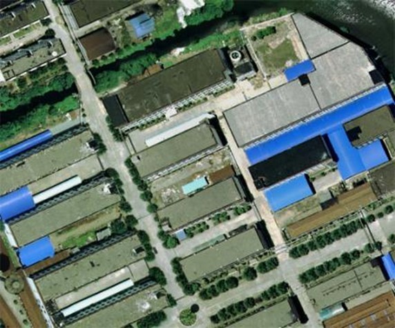
4.4kg lightweight 1500m long range highly integrated Airborne LiDAR
System PM-1500 with accuracy of 5mm@50m
PM-1500 Airborne LiDAR System is a high-precision and
long-range mobile laser measurement system independently developed
by Wuhan Hi-Cloud Technology Co., Ltd. It can be applied to
different carriers such as multi rotor UAV, VTOL fixed wing UAV,
small aircraft and helicopter. It can obtain dense high-precision
laser point cloud data on the ground on a fast flying mobile
platform. Integrated high-precision laser scanner, high-precision
POS (GPS, IMU) and other sensors, supported by the time
synchronization technology of independent intellectual property
rights and integrated multi-sensor integration technology, it can
synchronously obtain 3D laser point cloud and POS data, quickly
generate DSM, DEM and DOM and produce DLG and 3D models through a
complete set of data processing and application software.
It is widely used in survey grade mapping, digital 3D
modeling, topographic surveying and mapping, cadastral survey,
traffic survey, power line inspection, forestry survey, disaster
monitoring and other fields.
Detailed parameters of PM-1500
Items | Indicators | Parameters |
Laser Scanner | Wave Band | Near Infrared (Class 1 ) |
PRR | 100-2000Khz |
Maximum Measurement Range | 1000m@20% reflectivity |
1500m@60% reflectivity |
Range Accuracy | 5mm@50m |
Angular Resolution | 0.001° |
Scan Speed | 40-400 scans/s |
FoV | 75° |
Camera | Camera Resolution | 42.4MP |
Focal Length | 28mm |
POS System | Position Accuracy(post-processing) | Horizontal 0.01m |
Elevation 0.02m |
Orientation Accuracy(post-processing) | Heading 0.009° |
Pitch/Roll 0.005° |
System Performance | Dimension | 293×165×164mm |
Absolute Accuracy | horizontal <5cm |
vertical <5cm |
Weight | 4.4kg |
Multi Echo | 4 times |
Temperature and Humidity | Operation: -40℃~60℃, Humidity 85% |
Storage: -45℃~70℃, Humidity 85% |
System advantages of PM-1500
1. The overall structure of PM-1500 airborne laser measurement
system has been innovatively optimized. It highly integrates
sensors such as laser scanner, GPS, IMU and aerial survey camera,
etc. It is lightweight and easy to install. It is suitable for
multi platforms such as VTOL fixed wing UAV, multi rotor UAV and
helicopter.
2. The overall weight of the system is less than 4.4kg. It can
be easily carried by one person, whether by plane or high-speed
rail. Even if you go out to work with UAVs and other accessories,
an ordinary vehicle can load all of them, which is very convenient.
3. The ultra long ranging of 1500 meters greatly ensures the
operation safety in the environment of large topographic
fluctuation. At the same time, the ultra long ranging enables the
system to carry a flight platform with higher flight altitude and
faster speed, set a wider flight belt, and collect more point cloud
data at the same time, which greatly improves the point cloud
acquisition efficiency.
4. The super high frequency of up to 2 million points per
second makes the point cloud data more refined and can more truly
reflect the landform of the survey area, rather than fitting the
ground object coordinates. In addition, high frequency LiDAR
equipment can be equipped with UAVs with faster cruising speed, and
more data can be obtained in the same time.
5. High precision is the core demand in the field of surveying
and mapping. The ranging accuracy of PM-1500 airborne laser
measurement system can reach 5mm@50m, and the comprehensive
accuracy of the system is better than 5cm, meeting various
high-precision application scenarios.
6. PM-1500 airborne laser measurement system applies multi
echo technology. The laser scanning sensor in the system emits
laser pulses to penetrate the vegetation gap and reach the ground,
so as to obtain the terrain information under the vegetation. The
system can obtain up to 4 echo signals, and can penetrate trees and
feed back the most real surface information even in densely
vegetated areas.
7. PM-1500 is a new generation of high-precision airborne
LiDAR flagship system independently developed by Hi-Cloud. It has
the characteristics as long range, high point frequency, high
precision, stable overall performance, fair and generous price and
super cost-effective.
Pracital application projects of PM-1500
1. 3D City Model Project
Overview: The total area of the survey area is about 10 square
kilometers. It is necessary to obtain the original laser point
cloud and oblique image in the survey area, and generate the 3D
model according to the obtained original data.
Requirement: The laser point cloud obtained by airborne LiDAR
aerial survey technology and the digital image data taken by
oblique camera are used to generate Digital Elevation Model (DEM)
and Digital Orthophoto Map (DOM) and produce terrain model. At the
same time, the 3D model is generated based on laser point cloud
data and line drawing.
Solution: The project adopts PM-1500 LiDAR carried by UAV for
measurement. Take off and landing points shall be located with wide
vision and high altitude as far as possible.
Result:
DOM 3D Model