

Active Member
|
[China]

Address: No. 879, Ganghua Road, Hongguang Town, Pidu District, Chengdu
Contact name:admin

Chengdu Wanggan Technology Co., Ltd. |
|
|
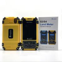
GPS Land Survey Equipment Mountain Slope Area Distance Measurement Tools
Built in barometer of this S4 land meter instrument, accurate to measure altitude. There is intelligent mountain area measurement mode in this device. The combination of barometer and GPS dual satellite positioning makes the measurement of mountain area more accurate and easy.
Mountain Measurement
1. In the main interface,press the [▲/▼] to switch function to “Mountain".
2. Press the [ Start] button to measure at the top of the mountain, and press the [Enter] button to confirm the information.
3. Press the [Enter] button and proceed from the foot of the mountain, walk around the foot of the mountain,and back to the starting point,press
the [Enter] button,then press the [Stop] button to end measure and view data.
4. Press "power" button to save the data.
Round-trip machine load
. At the Round-trip machine load in parameter setting,press the [▲/▼]button to set the width.
. After setting is completed,press the to return main interface.
. Press the [▲/▼]button switch function to Round-trip machine load"in the main interface.
. Press [Start] button at the starting point to start the measurement at the beginning of the work.Press the [Stop] button to pause measurement
and view data after agricultural machinery work is completed;If the measurement is not completed,press the [Start] button again to continue the
measurement. If the measurement is completed,press "power" button to save the data.


| Functions | S4 |
| Positioning accuracy | 2.5m |
| Initial barometric calibration | √ |
| Normal area measurement | √ |
| Mountain area measurement | √ |
| Intell. Slope measurement | √ |
| Fixed point measurement | √ |
| Fixed width area measurement | √ |
| Normal distance measurement | √ |
| Manual distance measurement | √ |
| Altitude display | √ |
| Altitude measurement | √ |
| Track display | √ |
| Mu setting | √ |
| Unit setting | √ |
| Time display | √ |
| Data statistics | √ |
| Historical record | √ |
| Lighting /Currency detection | √ |
| Dry battery | √ |
| lithium battery | √ |
| Data storage | 200 |
| Voice broadcast | √ |
| Data export | √ |


