

Active Member
|
[China]

Address: Rm.805 No.A Building ,Jindu Road 1128#,Minhang District ,Shanghai ,China Post Code 201108
Contact name:Rebecca Zhou

Shanghai Magcach Technology Co.Ltd |
|
|
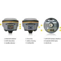
South RTK GPS Galaxy G1


MODEL:GALAXY G1
●Innovative structure design
●Powerful new bluetooth module
●Tilt survey
●Electronic bubble correct
●Full satellite constellations support
●Intelligent and open platform
●Cloud service
●Advanced data-link module
●NFC function
Features:
SOUTH Galaxy G1, new generation integrated RTK system with smaller size and innovative design, leads the direction of new generation RTK with excellent performance, provides high-efficiency and intelligent surveying experience to customers. It isn't simply smaller, it's better in everywhere.
Technical Specifications
Best Quality Measuring GNSS Receiver South Galaxy G1 gps gnss rtk receiver in dual frequency with best price and service
| SOUTH Galaxy G1 | |
| Surveying Performance | |
| Channel | 220 Channels |
| Signal Tracking | BDS B1, B2, B3, |
| GPS L1C/A, L1C, L2C, L2E, L5 | |
| GLONASS L1C/A, L1P, L2C/A,L2P, L3 | |
| SBAS L1C/A, L5( Just for the satellites supporting L5 ) | |
| Galileo GIOVE-A, GIOVE-B, E1, E5A, E5B | |
| QZSS,WAAS, MSAS, EGNOS, GAGAN, SBAS | |
| GNSS Feature | Positioning output rate: 1HZ~50HZ |
| Initialization time : <10s | |
| Initialization reliability : >99.99% | |
| Positioning Precision | |
| Code Differential GNSS Positioning | Horizontal: 0.25 m + 1 ppm |
| Vertical: 0.50 m + 1 ppm | |
| SBAS positioning accuracy: typically<5m 3DRMS | |
| Static GNSS Surveying | Horizontal: 2.5 mm + 0.5 ppm |
| Vertical: 5 mm + 0.5 ppm | |
| Real-Time Kinematic Surveying (Baseline<30km) | Horizontal: 8 mm + 1 ppm |
| Vertical: 15 mm + 1 ppm | |
| Horizontal: 8 mm + 0.5 ppm | |
| Vertical: 15 mm + 0.5 ppm | |
| Network RTK | RTK initialization time: 2~8s |
| Physical | |
| Dimension | 12.9cm × 11.2cm |
| Weigh | 970g(includiing installed battery) |
| Material | Magnesium aluminum alloy shell |
| Environmental | |
| Operating | -45ºC~+60ºC |
| Storage | -55ºC~+85ºC |
| Humidity | Non-condensing |
| Waterproof/Dustproof | IP67 standard,protected from long time immersion to depth of 1m |
| IP67 standard,fully protected against blowing dust | |
| Shock and Vibration | Not operating: Withstand 2 meters pole drop onto the cement ground naturally |
| operating : Withstand 40G 10milliseconds sawtooth wave impact test | |
| Electrical | |
| Power consumption | 2W |
| Battery | Rechargeable, removable Litium-ion battery |
| Battery Life | Single battery: 7h( static mode ) 5h( interual UHF base mode ) 6h( rover mode ) |
| Communications and Data storage | |
| I/O Port | 5PIN LEOM external power port + RS232 |
| 7PIN LEOM RS232 + USB | |
| 1 network/radio data link antenna port | |
| SIM card slot | |
| Wireless Modem | Integrated internal radio receiver and transmitter 0.5W/2W |
| External radio transmitter 5W/25W | |
| Working frequency | 410-470MHz |
| Communication protocol | TrimTalk450s, TrimMark3, PCC EOT, SOUTH |
| Cellular Mobile Network | WCDMA3.5G network communication module, GPRS/EDGE compatible, CDMA2000/EVDO |
| 3G optional | |
| Double Module Bluetooth | BLEBluetooth 4.0 standard, support for android, ios cellphoon connection |
| Bluetooth + EDR standard | |
| NFC communication | Realizing close range ( shorter than 10cm ) automatic pair between
Galxy G1 and controller (controller equipped NFC wireless communication module needed) |
| Data storage/Transmission | 4GB internal storage, more than 3 year raw observation data (1.4M/day) base on recording from 14 satelites Plug and play more of USB data transmission |
| Data Format | Differential data format: CMR+, CMRx, RTCM2.1, RTCM2.3, RTCM3.0, RTCM3.1, RTCM3.2 |
| GPS output data format: NMEA0813, PJK plan, cordinates binary code | |
| Network model support: various, FKP, MAC, supporting NTRIP protocol | |
| Intertial Sensing System | |
| Tilt survey | Built-in tilt compensator, correcting coordinates automaticlly according to the tilt direction and angle of the centering rod |
| Electornic Bubble | Conteroller software display electronic bubble, checking leveling status of the centering rod real time |
| User Interaction | |
| Buttons | One-button operation, Visual operation, convenient and efficient |


