

Active Member
|
[China]

Address: Room-1709,Building C,No.6 Xingzhi Road, Qixia District, Nanjing, Jiangsu Province, 210046, China
Contact name:zhou

Nanjing Hanzhong mapping equipment Co.,Ltd. |
|
|
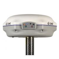
X900+ GNSS
The X900+ GNSS receiver from CHC leverages the latest GNSS technology by integrating 120 channels tracking GPS, GLONASS, Galileo and Compass and field software dedicated to topographic and construction surveying.
The X900 series is one of the most cost-effective GNSS receiver selected by large number of surveyors for its outstanding performances and reliability.
▪ Innovative and rugged design built for harsh environment
| GNSS Characteristics | |
| 120-channel signal tracking | GPS: L1, L2, L2C, L5 |
| GLONASS: L1, L2 | |
| SBAS: WAAS, EGNOS, MSAS | |
| Galileo: E1, E5A, E5B (test) | |
| BeiDou: B1, B2 (optional) |
| Advanced multipath mitigation technology | |
| Low noise carrier phase measurement |
| Performance Specifications (1) | |
| Real Time Kinematics (RTK) | Horizontal: 10mm+1ppm |
| Vertical: 20mm+1ppm RMS | |
| Initialization time: <10s | |
| Initialization reliability: >99.9% | |
| Post Processing Static | Horizontal: 5mm+1ppm RMS |
| Vertical: 10mm+1ppm RMS | |
| Communications | |
| 1 RS232 serial port | |
| 1 high-speed USB | |
| Integrated Bluetooth ® class 2 | |
| Integrated GSM/GPRS modem | |
| CHC radio modem internal Rx | 430-450/450-470 MHz |
| Optional radio modem(2) | Internal Rx/Tx: 403-473 Mhz |
| External Tx DL5: 1W-20W adjustable | |
| Protocols | RTCM2.1, RTCM2.3, RTCM3.0, CMR, CMR+ and RTCA |
| NMEA0183 output | |
| RINEX and HCN outputs for GNSS raw data | |
| Data Storage | 4 GB internal memory |
| GPS device mounts as a USB external hard device |
| Physical | |
| Size (LxWxH) | 190 x 200 x 84 mm (7.5 x 7.9 x 3.3 in) |
| Weight | 1.4 kg with battery (49 oz) |
| Working Temperature | -40 °C to +65 °C (-40°F to 149°F) |
| Storage Temperature | -40 °C to +75°C (-40°F to 167°F) |
| Humidity | 100% condensation |
| Dustproof | IP67 |
| Waterproof | Protected from temporary immersion to depth of 1 meter, floats. |
| Shock | Survives a 2−meter drop on to concrete |
| Electrical | |
| Typical power consumption | 2.6W |
| Battery capacity | 2200mAh |
| Operating times on internal battery | typical 5 hours in RTK mode |
| External power input | 9-18VDC |
| Software(optional) | |
| CHC’s Landstar field data collection software | |
| Carlson’s SurvCE field data collection software | |
(1) Accuracy and reliability specifications may be affected
by multi path, satellite geometry and atmospheric conditions.
Performances assume minimum of 5 satellites, follow up of
recommended general GPS practices. (2) UHF type approval are
country specific. Specifications are subject to change without
notice.


