

Active Member
|
[China]

Address: No.9-10, Jintai Building, Nanping Xi road, Nan'an Distract
Contact name:Silvia.Liu

Chongqing Gold Mechanical& Electrical Equipment Co.,Ltd |
|
|
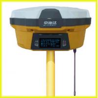
V60 Satellite Navigation Land Survey GPS
The V60 GNSS RTK DGPS survey equipment system is designed to meet high quality standards at an affordable price. It is outstanding in it's class, with a rugged design and user-friendly functions.
*Main Specification of the V60 Land Survey GPS
---------------PERFORMANCE SPECIFICATIONS----------------------------------
***MEASUREMENTS***
• 220 Channels
• Advanced Pacific Crest Maxwell 6 Custom Survey GNSS Technology
• High precision multiple correlator for GNSS pseudo range measurements
• Unfiltered, unsmoothed pseudo range measurements data for low noise, low multipath error, low time domain correlation and high dynamic response
• Very low noise GNSS carrier phase measurements with <1 mm precision in a 1 Hz bandwidth
• Signal-to-Noise ratios reported in dB-Hz
• Proven Pacific Crest low elevation tracking technology
***Satellite signals tracked simultaneously***
GPS: Simultaneous L1C/A, L2C, L2E, L5
GLONASS: Simultaneous L1C/A, L1P, L2C/A (GLONASS M only), L2P
SBAS: Simultaneous L1 C/A, L5
Galileo: Simultaneous L1 BOC, E5A, E5B, E5AltBOC
BDS/Compass: B1, B2
QZSS: L1 C/A, L1 SAIF, L2C, L5
------------------------POSITIONING PERFORMANCE-----------------------------
***Static and Fast Static GNSS surveying***
Horizontal: 2.5mm+0.5ppm RMS
Vertical: 5mm+0.5ppm RMS
***Post Processing Kinematic***
(PPK / Stop & Go) GNSS surveying
Horizontal: 1cm+1ppm RMS
Vertical: 2.5cm+1ppm RMS
Initialization time: typically 10 minutes for base while 5 minutes for rover
Initialization reliability: typically > 99.9%
Real time Kinematic (RTK) surveying
Horizontal: 8mm+1ppm RMS
Vertical: 15mm+1ppm RMS
Initialization time: typically < 8 seconds
Initialization reliability: typically > 99.9%
Code Differential GNSS positioning
Horizontal: 25cm+1ppm RMS
Vertical: 50cm+1ppm RMS
SBAS: 0.50m Horizontal, 0.85m Vertical
--------------------------------------HARDWARE-----------------------------------
***Physical***
Dimensions (W x H): 18.20cm x 9.80cm (7.17 in x 3.86 in)
Weight: 1.25kg (2.76lb) without internal battery
Operating temperature: -45℃ to +65℃ (-49℉ to +149℉)
Storage temperature: -55℃ to +85℃ (-67℉ to +185℉)
Humidity: 100%, considering
Water/dustproof: IP67 dustproof, protected from temporary immersion to depth of 1m (3.28ft).
Shock and Vibration: Designed to survive a 3m (9.84ft) natural fall onto concrete.
***Electrical***
Power 6V to 28V DC external power input
Power consumption ≤3.5W
Automatic Switching between internal power and external power
Rechargeable, removable 7.4V, 5000mAh Lithium-Ion battery in internal battery compartment
***Internal battery life***
Static 13 - 15 hours
RTK Rover (UHF/GPRS/3G) 10 - 12 hours
RTK Base 8 - 10 hours
***I/O interface***
1 x Bluetooth
1 x standard USB2.0 port
1 x TNC UHF connector
2 x RS232 serial port
2 x DC power input (8-pin & 5-pin)
1 x Micro SD card port
--------------------------COMMUNICATION AND DATA STORAGE-----------------
***3G Communication***
Fully integrated, fully sealed internal 3G, compatible with GPRS
Network RTK (via CORS) range 20-50km
***HI-TARGET internal UHF radio (standard)***
Frequency: 450~470MHz with 116 channels
Transmitting Power: 1W, 2W, 5W adjustable
Transmitting Speed: 9.6Kbps, 19.2Kbps
Working Range: 5km typical, 8~10km optimal
***Pacific Crest internal UHF radio***

