Handheld GPS RTK Survey Device Qstar8 handheld GPS GNSS RTK
Equipment
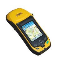
Qstar8 brings the essential functionality for high accuracy GIS
data collection in one device. It is also the most cost-effective
high accuracy network RTK rover.
System Features:
Shining Points
Faster
Microsoft Windows Mobile 6.5
806MHZ high-speed CPU
256M RAM, 8G flash memory
Higher accuracy
GPS+GLONASS+COMPASS
Advanced PPP technology
Solider
1.5M anti-drop, IP67
Integrated elaborate double color model
Main features
5 million pixel auto focus camera
Accurate centering mode
Integrated high accuracy G-sensor, Centering GNSS antenna phase
center accurately
Electronically level GNSS antenna
Multiple wireless communication modes
Integrated 3G communication function, Supports all 3G communication
systems
Integrated Bluetooth, WIFI, USB communication , Makes wirelessly
assist telemeter &detecting instrument etc. to work
synchronously.
GNSS positioning technology
With reliable GPS+GNSS positioning technology, you can work
normally even under hard environmental conditions.
Support COMPASS satellite navigation system.
Advanced PPP technology realizehigher accuracy even just adopt
single point positioning.
3.7 inch QVGA TFT, resolution: 640×480
8800mAh Li-ion battery, over 12 hours’ continuous work
Qstar 8
The most portable handheld RTK
Centimeter level high accuracy
Dual frequency GPS+ GNSS positioning
Meet your surveying requirements even under hard environmental
conditions and most extreme weather conditions
Qstar 6
Sub-meter level accuracy
Flexible operation mode
GPS+ GNSS positioning
Qstar 5
Meters level high accuracy
Receive SBAS to get high accuracy within 1M
Bluetooth & WIFI realize Wireless Collaborative Operation