Home Companies Chongqing Gold M& E Equipment Co., Ltd.

high precision 220 channel gps glonass receiver hi-target h32 gnss

Chongqing Gold M& E Equipment Co., Ltd.
Active Member

Contact Us

[China] country

Address: 9F/10,Jintai Building,Nanping,Chongqing,400060,China

Contact name:Ceilin Wang

Inquir Now

Chongqing Gold M& E Equipment Co., Ltd.

high precision 220 channel gps glonass receiver hi-target h32 gnss

Country/Region china
City & Province chongqing chongqing
Categories Other Security & Protection Products
InquireNow

Product Details

H32 GNSS RTK System
 
Originated from HI-TARGET’s sophisticated GNSS technology, the H32 is a very competitive GNSS RTK system on the current market with its rugged design and affordable price.
 
The H32’s housing is made of General Electric Xenoy 5220U polymer resin to handle severe and harsh filed conditions. With its unique internal design, it can perfectly avoid or lessen obstruction and multipath effect to ensure superior positioning capability.
 

The H32’s front control panel with super bright OLED display screen (Resolution 128x64) makes the work more intuitive. No matter it is in the dark or strong sunshine, the screen is comfortably readable to eyes.   


KEY FEATURES

Multi Constellation Tracking

120 channels. The H32 is fully compatible with GNSS constellations to track GLONASS, GALILEO, SBAS as well as GPS.
 
All-in-one Transceiver UHF Radio
The transceiver UHF radio enables the H32’s working mode to be switchable between base and rover in the same receiver. The H32 provides excellent performance in UHF RTK operation with its built-in transceiver UHF radio, which has adjustable transmitting power from o.1 Watt to 2 Watts. 
 
Seamlessly Operation in CORS System
With internal GPRS modem, the H32 works perfectly with corrections from CORS networks in any version of CMR, RTCM without needing to interpret the message but reading seamlessly.
 
Powerful Battery
Powered by 4400mAh Li-Ion battery.
Static working time 13 - 15 hours
RTK Rover (UHF/GPRS) working time 10 - 12 hours
RTK Base working time 8 - 10 hours
 
Rugged design, IP67
The special latching technology on flexible flat cables ensures trouble-free operation under impact or vibration. The H32 withstands 2 meters natural fall onto concrete.
 
Field Controller and Software
There are optional field controllers and software in the H32 package. The controllers with OS Microsoft Windows Mobile 6.5 are fully compatible with the third party software such as Carlson SurvCE, MicroSurvey FieldGenius, Digiterra Explorer, Esri ArcPad etc. besides standard field&GIS software made by HI-TARGET. HI-TARGET controller with WiFi, Bluetooth, and GPRS/3G is completely wireless to connect to any device, collect data and connect to server simultaneously and seamlessly.
 
Post-processing Software
HI-TARGET Geomatics Office (HGO) software provides total GNSS solution with a complete suite of programs to support HI-TARGET GNSS receivers. Standard Rinex data and HI-TARGET raw data can be processed flexibly and easily.
MEASUREMENTS
• 120 Channels
• Proven NovAtel GNSS technology
• Multipath mitigating technology
• Auxiliary strobe signals, including a configurable output for time synchronization and mark inputs
GPS: L1, L2, L2C
GLONASS: L1, L2
Galileo: E1
GIOVE-A/GIOVE-B (test)
BDS/Compass
SBAS
QZSS
 
POSITIONING PERFORMANCE[i]
 
Static and Fast Static GNSS surveying
Horizontal: 2.5mm+0.5ppm RMS
Vertical: 5mm+0.5ppm RMS
 
Post Processing Kinematic
(PPK / Stop & Go) GNSS surveying
Horizontal: 1cm+1ppm RMS
Vertical: 2.5cm+1ppm RMS
Initialization time: typically 10 minutes for base while 5 minutes for rover
Initialization reliability: typically > 99.9%
 
Real-time Kinematic (RTK) surveying
Horizontal: 10mm+1ppm RMS
Vertical: 20mm+1ppm RMS
Initialization time: typically < 10 seconds
Initialization reliability: typically > 99.9%
 
Code Differential GNSS positioning
Horizontal: 25cm+1ppm RMS
Vertical: 50cm+1ppm RMS
SBAS: 0.60m Horizontal
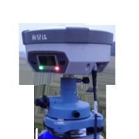
 
HARDWARE
 
Physical
Dimensions (w x H): 16.5 cm x 10.5 cm (6.50 in x 4.13 in)
Weight: 1.75kg (3.86lb) with internal battery, internal radio, standard UHF antenna
Operating temperature: -45to +65 (-49 to +149)
Storage temperature: -55 to +85 (-67 to +185)
Humidity: 100%, considering
Water/dustproof: IP67 dustproof, protected from temporary immersion to depth of 1m (3.28ft).
Shock and Vibration: Designed to survive a 2m (6.56ft) natural fall onto concrete.
Display: 128×64 resolution, 1.54 inch OLED screen
 
Electrical
Power 6V to 28V DC external power input
Power consumption 2.5W
Automatic Switching between internal power and external power
Rechargeable, removable 7.4V, 4400mAh Lithium-Ion battery in internal battery compartment
 
Internal battery life
Static 13 - 15 hours
RTK Rover (UHF/GPRS) 10 - 12 hours
RTK Base 8 - 10 hours
 
I/O interface
1 x Bluetooth
1 x standard USB2.0 port
2 x RS232 serial port
2 x DC power input (8-pin & 5-pin)
 
COMMUNICATION AND DATA STORAGE
 
GPRS/GSM
Fully integrated, fully sealed internal GPRS/GSM
Network RTK (via CORS) range 20-50km
 
HI-TARGET internal UHF radio (standard)
Transmitting Power: 0.1W, 1W, 2W adjustable
Transmitting Speed: Up to 19.2Kbps
Working range: 3~5Km typical, 8~10km optimal
 
HI-TARGET External UHF radio (standard)
Frequency: 460 MHz with 116 channels
Transmitting Power: 5W, 10W, 20W, 30W adjustable
Transmitting Speed: Up to 19.2Kbps
Working Range: 8~10Km typical, 15~20km optimal
 
Support other external communication device
For example, external GSM modem.
 
Data storage
64MB internal memory
 
Data formats
(1Hz positioning output, up to 50 Hz - depends on installed option)
CMR: CMR+, CMR input and output
RTCM: RTCM 2.1, 2.3, 3.0, 3.1 input and output
RTCA: RTCA
Navigationoutputs: NMEA-0183, NovAtel ASCII and Binary logs


Hot Products

Deep Rotary Borehole Camera for CCTV Borehole Inpsection Water Well Inspection Camera Features: 1...
CCTV Inspection Camera Borehole Video Inspection Camera Pipeline Camera Main Control Box: 12V DC ...
GYGD 500m water well optical inspection camera borehole inspection A wide range of Laval fully ...
High Resolution Drilling Borehole Imaging Device Wireline Borehole Wall Imaging Tools Optical ...
Borehole Camera Scans Downhole Video Camera Water Borehole View Water Well Wall and Center Technical ...
Underground Borehole Video Image Geographic Surveying Inspection Machine Main application: ...