

Active Member
|
[China]

Address: ROOM 326,MOMA TOWER, No.199 CHAOYANG NORTH ROAD, BEIJING P.R.CHINA
Contact name:liu

Beijing Youbang Jiantong Surveying Instruments Sales Co., Ltd |
|
|
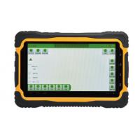
The HV-T70 is a high-performance, fully protected, touch-sensitive, Beidou dual-system industrial handheld tablet, based on a 1.7G Hz eight-core processor, powered by the latest Android 7.0-inch capacitive touchscreen, built into wifi 802.11 A / B / G / N (2.4 GHz / 5 Ghz), and 4G All-Netcom. Use the most advanced structure design, light, easy to carry, durable, built-in high capacity battery, to ensure long-time field work. And has industry-level three-prevention standards. Can be widely used in agriculture, forestry, water conservancy, industrial control, medicine Treatment, telecommunications, power, multimedia, defense, surveying and mapping, industrial automation equipment, manufacturing and other fields, is a cost-effective industrial grade handheld terminal equipment.
Technical specifications:
Technical specifications
| Operating system | Google Andriod 7.0 | |||||||||||
| Hardware | and | (OS) | ||||||||||
| software platform | Processor | Cortex A7 1.7 G Hz X8 (eight-core processor) | ||||||||||
| Figure processor | Mali-T720 | |||||||||||
| Built-in storage | 3GB RAM+32GB ROM dual one low power storage | |||||||||||
| Memory | Storage extension; | Micro SD card (T-FLASH card) card reader with maximum support for | ||||||||||
| storage expansion | 64GB extension | |||||||||||
| Size (mm) | 202*138*22mm | |||||||||||
| Outline | Color material | gray | ||||||||||
| Weight (g) | 690g | |||||||||||
| Communication | & | Call function | All-Netcom | 4G; GSM voice | calls; | WCDMA | voice and | video calls; | ||||
| TD-SCDMA | ||||||||||||
| network | ||||||||||||
| 4G data | WCDMA | 3.75G (HSDPA | 42.2 | Mbpss, | HSUPA | 11.5Mbps) | ||||||
| TD-SCDMA-enabled WiFi routing sharing | |||||
| EDGE | Support | ||||
| GPRS | Support | ||||
| WAP | Support | ||||
| WI-FI | Support | ||||
| Bluetooth | Support for BT4.0 LTE low power consumption (A2DP EDR) | ||||
| Screen&touch | Screen size | 7-inch HD IPS / AFFS display | |||
| Resolution ratio | Visible in the bright sunlight of 1280 1000 lumens | ||||
| screen | |||||
| Touch screen | Multitouch capacitor screen | ||||
| Main camera | 13 million pixels with autofocus and electronic flash | ||||
| Camera | 13 | million | pixels | ||
| with | autofocus and | 8 million pixel camera | |||
| electronic flash | |||||
| Direction sensor | Support | ||||
| Gravity sensor | Support | ||||
| Dip inductor | Support | ||||
| Linear acceleration | Support | ||||
| sensor | |||||
| Sensor | Rotating | vector | Support | ||
| sensor | |||||
| Proximity | Support | ||||
| transducer | |||||
| Ambient | light | Support | |||
| sensor | |||||
| Gyroscope sensor | Support | ||||
| Cell | 11000 Ma lithium polymer battery to ensure long working and standby | ||||
| time | |||||
| SIM card | 1.8 / 3.3V standard SIM card | ||||
| Interface & battery | TF card interface | Micro SD card (T-FLASH card) card reader with maximum support for | |||
| 128GB extension | |||||
| Earphone interface | Four-segment 3.5mm standard headphone interface (US Standard) | ||||
| Data interface | Standard USB for Quick change 2.0 Quick charge | ||||
| Module type | GPS& Beidou dual-mode positioning module / Beidou / support | ||||
| SBAS/A-GPS/ | |||||
| GNSS | |||||
| Positioning | Single point accuracy: 1-3 m / SBAS accuracy: 1-2 m | ||||
| accuracy | |||||

| Renewal frequency | 1Hz | ||||||
| FM radio function | Digital FM radio | ||||||
| Apolegamy | Support for RFID, support for NFC | ||||||
| video | frequency | 1080P video playback support H.264, MPEG4, H.263 support File | |||||
| (V.F.) | format: RM, | ||||||
| Audio frequency | Handset, | microphone, loudspeaker | 3.5mm standard headphone | ||||
| interface | |||||||
| Function extension | |||||||
| English, Spanish, Portuguese (Brazil), Portuguese (Portugal), | |||||||
| Italian,German, Dutch, French, Polish, Romanian, Turkish, Russian, | |||||||
| Language | Arabic, | Indonesian,Malay, Thai, | Vietnamese, Hindi, Hebrew, | ||||
| Simplified,Chinese, traditional Chinese, etc. | |||||||
| The data collection of points, lines and surfaces is realized, and the | |||||||
| Acquisition | and | track and route are recorded at the same time, the functions of route | |||||
| planning and navigation along the road are realized, and the | |||||||
| navigation software | professional data such as contour map, topographic map, satellite map | ||||||
| and so on can be loaded | |||||||
| Seismic movement | 1-19Hz / 1.0mm amplitude 19-200Hz / 1.0g acceleration | ||||||
| Shock resistance | MIL-STD-810G / R 516.6 / Procedure IV military Protection Class | ||||||
| Waterproof | and | Class 7 waterproofing: 1. 2 meters in water depth waterproofing not | |||||
| dustproof grade | less than 30 minutes | ||||||
| Earthquake | Natural fall within 1.6 meters of earthquake resistance; | ||||||
| protection grade | |||||||
| Industrial design | |||||||
| Working | -30°C - 75°C | ||||||
| temperature | |||||||
| Storage | -40°C - 80°C | ||||||
| temperature | |||||||
| Relative humidity | 5% to 95% in non condensate state | ||||||
| operational altitude | Maximum working height: 4500m (15000 ft) | ||||||


